BioGeoChemistry of Tidal Flats
The time-series station
Muddy coasts are a typical feature of the south-eastern North Sea. Their morphodynamics and physical water-column dynamics and ecology have been a subject of extensive studies. However, the fundamental physical, chemical and biological interactions characterizing the existence and dynamics of these coastal zones have not yet been subject of systematic investigations. To obtain a better understanding of these complex dynamic processes, the interdisciplinary research programme BioGeoChemistry of Tidal Flats has been established. Our Sub-Project 3 has the following goals:
- to investigate the budget of matter fluxes between tidal flats and open coastal waters, and of matter transformation in the tidal flat water column and the sediments
- to understand the exchange processes between sediment and water column
- to understand the relevance of external factors which control the substance transport and transformation such as storms, spring tides, and ice during extreme winter conditions
 The study area of the project is the East-Frisian Wadden Sea, with a focus on the region of Spiekeroog island. In the first phase of the project, data were mostly collected during ship cruises in the backbarrier tideways and in the adjacent coastal zone. However, these expeditions were generally limited to a few days only. Moreover, cruise time was not available during the winter months when the most relevant processes affecting the tidal flats are assumed to take place due to storms and high tides.
To achieve better conditions of a continuous data availability, a time-series station was set up in summer 2002 in the tidal inlet of Spiekeroog island, i.e. in a position separating the backbarrier tidal flat and the open coastal waters. The purpose of the station is to provide continuous data on physical, biological and chemical parameters in the water column during all-weather conditions.
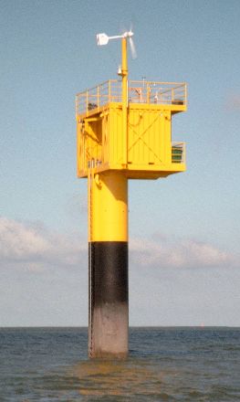
The time-series station was erected in the tidal inlet of Spiekeroog island at position 53°45'01.00" N, 007°40'16.30" E. The bottom depth at this location is 13 m below Mean Sea Level (Normalnull NN).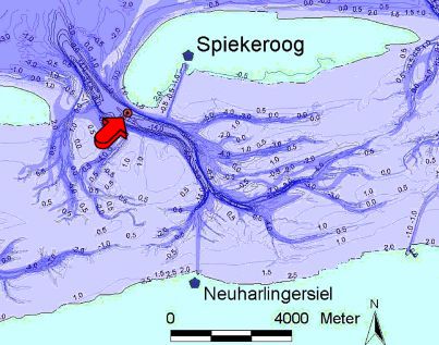 The station and its location are marked with a red dot in the Spiekeroog tidal inlet. Contour lines indicate water depths below Mean Sea Level (map made available by Heike Grotlüschen, ICBM). The station has been designed for a full-year operation, with a stability to withstand ice conditions of up to 50 cm ice thickness and wave heights as they typically occur in that region during winter. The mechanical structure consists of a pole, driven to 10 m depth into the sediment, and a plat-form on top of the pole about 7 m above the mean sea level, equipped with two containers.
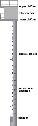
The containers carry a second platform where a wind energy converter and solar panels are installed for achieving an autonomous electrical power supply of the station, and the antenna of a beam radio link system for data transfer to a receiving station on Spiekeroog island. From there the data are fed to the University of Oldenburg via telephone network and published in the internet.
Meteorological sensors are installed on the upper platform as well as an electric winch for profiling underwater measurements using hydrographic probes. However, profiling measurements are mostly restricted to the period of spring to autumn since waves, tidal currents and ice during winter would be a high risk for the sensors. To overcome these limitations and to allow for a continuous data sampling also during extreme weather conditions, sensors can also be used inside the pole under well-protected conditions.
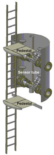
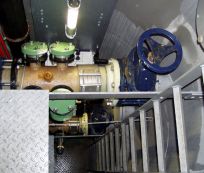
This feature of the station has been realised by inserting into the pole a concrete sealing compound at the level of the seafloor, which prevents water intrusions via sediment. Rigidly mounted vertical access ladders between the upper exit and the concrete sealing, and five platforms at different depths between sea surface and bottom, allow a safe access to the pole. For the integration of sensors, specific tubes have been installed into the pole at different water depths with a horizontal orientation along the main tidal current direction, thus leading to a continuous flow of seawater to sensors which can be attached through mounting flanges.
|
Schematics of the station (right), with a partial view into the pole with mounted access ladders and platforms. The used sensor tubes are marked with clear openings. A detailed view into the pole (left) shows the ladder and platforms, and two sensor tubes. The vertical tube in the background serves to feed fresh air to depth during operations inside the pole. |
|
|
|
|
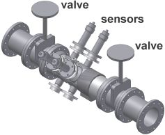
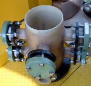
Schematic view of a sensor tube (left), with four flange-connected instruments in upward orientation. Two downward looking flanges are shown without instruments. To avoid mechanical stress due to deformations of the pole, the sensor tube is split into two parts which are connected by a compensator, shown as a dark ring to the right of the sensor flanges. The sensor tubes are made of epoxy-glass resin (middle) which has a better resistance to bio-fouling than steel. Due to its light weight it is easy to handle during service. Cam slide valves at each end of the sensor tubes (right) allow the pole to be sealed against water intrusion before disassembling the set-up.
System parameters of the time-series station
| Mechanical dimensions
|
Pole: 35 m length, 1.6 m diameter, thickness of wall 22 mm
Platforms: 5,10 m x 3,60 m Two containers, each 3.0 m x 1.2 m |
| Electric energy
|
750 W wind energy converter; 120 W solar panels;
2500 Ah 24 V batteries; 2 kW 230 V AC gas generator |
| Data management
|
Industrical PC |
| Telemetry | point-to-point radio link to relay station on Spiekeroog island with 2 MB/s data rate;
transfer to land station with ISDN telephone network |
| Meteorological sensors
|
temperature, wind speed and direction (Lambrecht);
downwelling irradiance, water leaving radiance (TriOS RAMSES |
| Sensor tubes | at 1.5 - 3.5 - 5.5 - 7.5 - 9.5 m above seafloor (operating);
at 0.5 - 2.5 - 4.5 - 6.5 - 7.5 - 11.5 m above seafloor (optional) |
| Instruments attached to sensor tubes | temperature and conductivity (-4H- Jena engineering) at 1.5 - 3.5 - 5.5 - 7.5 - 9.5 m above seafloor;
oxygen concentration (Clark cell) and pressure (-4H- Jena engineering) at 1.5 m above seafloor |
| Other instruments installed
in the pole |
prompt and delayed chlorophyll fluorescence (TriOS DF)
gelbstoff and protein-like fluorescence (Uni OL) |
| Electric winch
|
Installed on upper platform; 6-conductor cable; load 400 N max
|
| Profiling instruments operated by winch
(in preparation) |
temperature, conductivity, pressure, oxygen and redox potential (Sea-Bird SBE19plus);
hyperspectral self-calibrating transmissometer (TriOS MST |
| Other instruments
|
Acoustic Doppler Current Profiler (operated by Senckenberg Institute)
current velocity and direction at 1 m above seafloor (hs engineers) dissolved methane (CAPSUM) Nutrients: nitrate, nitrite, ammonia, phosphate, silicate (SYSTEA) dissolved manganese (ZAPS Technologies) |
| <<back | Publications | More details
|